EU-PAPFor Achieves Conservation Planning in Sierra Leone’s Gola Forest
The EU PAPFor project aims to help the locals manage and protect the natural resources of the Gola Rainforest National Park.
By James Mambu Kpargoi
The Gola Rainforest, with a size of 35,000 hectares, is one of West Africa’s remaining biodiversity reserves, which plays a critical role in regulating global climate and directly sustains the lives of millions of people, and thousands of high conservation value species, including the White-necked Picathartes, Pygmy Hippo, Jentink’s Duiker, and the Western Chimpanzee among others. However, deforestation and threats, including farming, logging, mining, and associated activities have increased remarkably in recent years.
Considering the inherent threats to this vital ecosystem, land management was a matter of urgency. In 2020, BirdLife Partner, the Conservation Society of Sierra Leone (CSSL), under the European Union (EU)-funded Support Program for the Preservation of Forest Ecosystems in West Africa (PAPFor) launched the PAPFor Community Forest and Land Use Planning and Mapping Project. Working with the communities, the project aims to help the locals manage and protect the natural resources of the Gola Rainforest National Park and Tiwai Island priority conservation landscapes by establishing chiefdom/community forestry and land use planning that can be managed by the locals.
Land use planning is a systematic and iterative procedure implemented to create an enabling environment, for the sustainable development of land resources, to meet the needs and demands of inhabitants. It assesses the physical, socio-economic, institutional, and legal potential and constraints to optimal and sustainable use of land resources and empowers people to decide how to allocate those resources.
“The completion of Land Use Planning for two chiefdoms with more than eight communities is a significant achievement for the communities and CSSL. Land Use Planning ensures careful utilization of community forestry in a sustainable manner, in which the communities can benefit from essential ecotourism services. It would also ensure the prioritized use of the land in a systematic manner and control logging, mining, and other activities that are harmful to the forest” , said Emurana Sowa, CSSL Coordinator of the PAPFor Project.
To date, has successfully engaged seven chiefdoms: Koya, Gaura, Barri, and Makpele, in Pujehun district, and Niawa, Nomo, and Tunkia in Kenema district for community forestry and two chiefdoms: Koya and Gaura, for land use mapping and planning. The mapping exercise covered all the communities within the seven chiefdoms classified as the Gola Rainforest National Park (GRNP) landscape areas.
Land use planning clarifies and secures communal tenure in forest areas and is increasingly becoming fundamental to good land and forest governance. Targeting seven community forests, CSSL has cleared dispute-free boundaries of the reserves. Further, CSSL has produced maps with the full participation of the local authorities and land-owning families.
The overarching goal of the exercise is to obtain detailed knowledge of the uses of the land in terms of zones of use (production and cultivation zones, residential zones, cultural uses, and a non-exhaustive list) of the villages present in the zone proposed for community mapping activities. Through this, a detailed and geo-referenced land use map of the villages/land/territories to facilitate the implementation of land use management plans has been developed
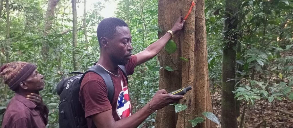
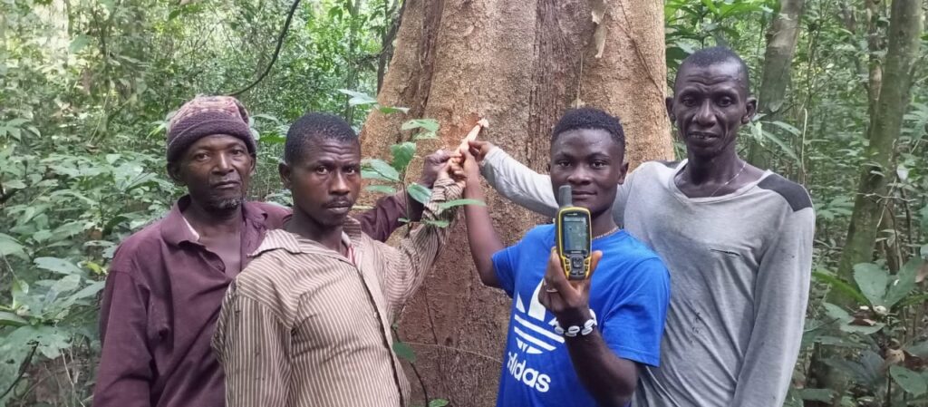
“Trackers were included to identify the physical boundaries between and within communities and chiefdoms. There were validations of the draft maps produced at the community and chiefdom levels, and final maps incorporating all the corrections and showing high conservation zones produced”, explained Patrick Dauda, Coordinator of Land Use Planning of PAPFor.
In close collaboration with the Ministry of the Environment and the Gola Rainforest Conservation-LG (GRC-LG), CSSL successfully developed and implemented all the activities that achieved the effective establishment and operationalization of Community Forests and Land Use Planning and Mapping of the entire GRNP landscape.
“Unregulated demand for land poses clear risks for both our communities and our forests in this region. Therefore, clarifying and securing the boundaries of conservation zones, while securing the right to manage the ecosystem, is a generally accepted feature of good natural resources governance that invariably protects the environment. As a community, we are very grateful to CSSL and the donors for this initiative”, said Mohamed Koroma, a resident of Njala community, Gaura chiefdom while expressing his delight.
Quite remarkably, CSSL adopted a bottom-up approach to land use planning which integrated community rights and local requirements by establishing maps of the community forests through participatory mapping activities and participatory mapping approach to obtain precise information on the management of natural resources and the use of land by the communities.
The community/participatory mapping work represents the whole community, including the traditional authorities, who are the leading managers and beneficiaries of the land resources. Care was taken to include different socio-professional profiles in the mapping workshops to represent all community groups. Workshops and qualitative interviews were conducted with the community of each locality through different groups to involve a greater homogeneity of the people consulted.
“We were involved throughout the process of and use planning. We are very happy that our forest will now be used to improve our livelihoods. Knowing the boundaries of our forest and the area set aside for the community forest has prevented people from destroying the environment. A few years ago, we were gradually confronted with drought as our only source of water was drying out but following PAPFor, we stopped destroying our forest and now our water sources are all good. We have limited all the practices that destroy the forest and declared our forest conservation zones”, noted Abdul Borbor Musa, Chair of the Gaura Chiefdom’s Community Forest Management Committee.

During the process, the area of the proposed land use planning and mapping was considered based on physical, ecological, and human characteristics. Large towns, for example, were avoided as much as possible, while the forests and rivers were ideally targeted for delimitation of provisional boundaries.
The project also guaranteed control by the communities. The communities were given tremendous power and control over information about the production process and the use of land/territory.
The entire chiefdom was represented at all levels which ensured support for the plans. Allowing us the locals to be engaged by respecting our knowledge of the land and its resources, minimizing conflict, and promoting the health of the environment. CSSL helped us to develop our land-use plans that support our goals for the future and balance the different land uses in ways that will make our vision a reality” , said Lahai Nyallay an elder from Joru town, headquarters of the chiefdom.
CSSL PAPFor is currently establishing seven Community Forest Management Committees or governance structures across 6 chiefdoms in the Gola Rainforest National Park Landscape and one Chiefdom in the Kambui Hills Forest Reserve Landscape.

Header image: Land Use Mapping Exercises © Patrick Dauda

“The completion of Land Use Planning for two chiefdoms with more than eight communities is a significant achievement for the communities and CSSL.“
Emurana Sowa, CSSL Coordinator of the PAPFor Project.